“Apocalyptic” Fires Ravage Across the West Coast
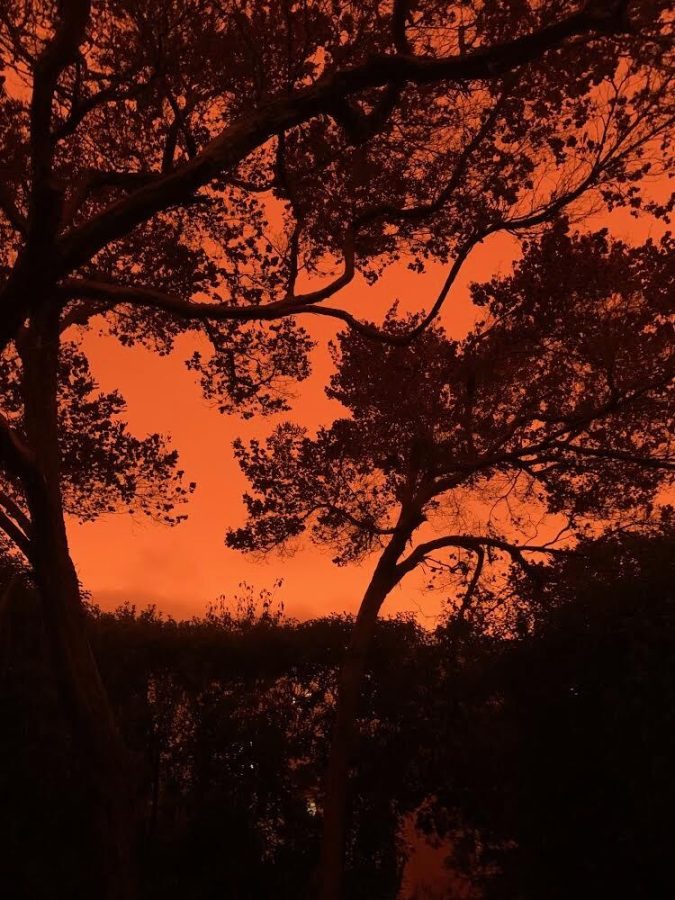
A typical view of the San Francisco Bay, disguised by an orange sky.
September 23, 2020
“Apocalyptic” has been the favored description these days when discussing the fires blazing along the West Coast. Photos of heavy layers of smoke creating a warped, vibrant orange sky fill the news as we come to face another challenge this year.
When several thunderstorms took to the coast, lightning strikes on Aug. 16 and 17 sparked blazes on land that had been drying out from record-breaking high temperatures during the previous months. Coupled with a high-pressure zone that pushed hot, dry winds towards the West which would normally be moving east this time of year, the National Weather Service called the encounter a “twice in a century” type of wind, creating the perfect storm.
Since the fires have begun, at least 34 people have died and 5.8 million acres have burned, marking the worst fires the country has seen in 18 years. Half a million people have fled their homes, national parks have been closed and firefighters have been brought in from as far as Australia to help contain the fires.
California, as the largest state on the coast, has experienced the majority of wildfires and fills most of the headlines. With a far drier climate than Oregon and Washington, it is no surprise that 3.4 million of the acres that have burned are within the state.
The August Complex, one of the major fires started since summer, is California’s largest wildfire in history. Beginning as 38 smaller fires, it has burned over 800,000 acres — larger than the state of Rhode Island — through the coastal section of Northern California in Lake, Mendocino, Trinity, Tehama and Glenn counties. The August Complex is considered to be roughly 30% contained. Additional fires besides the August Complex have reached major areas including Sonoma County, Big Sur, Los Angeles and San Diego.
While California’s typical wildfire season runs until September and October, over 17,000 firefighters are working to slow the spread of the flames. Nine national forests have been reopened and winds along with temperatures have dropped slightly, although professionals say that the temperature drop is likely to be due to a substantial layer of smoke between the state and the sun. Snippets of information like these seem hopeful, but weather forecasts for the upcoming weeks do not look promising. The mass amounts of dead trees and dry foliage from the major drought in California are only conducive to fueling more fires. The U.S. Forest Service warns against any form of ignition near dense foliage, as the next several weeks are expected to be dry.
Unlike California, Oregon and Washington tend to have more rainfall; nonetheless, fires have rampaged there as well.
For the first time in history, Oregon has five megafires — fires covering at least 100,000 acres — burning at once. Entire towns have been wiped out as these fires introduce an entirely new geographic threat to the region. Widespread burning removes vegetation that would naturally slow the fall on debris and changes chemical compositions of soil aid in the slippage, worrying local officials. The Beachie Creek Fire, located on the west side of the Cascade Mountains, has given way to mudslides and flash floods.
Predicted rainfall in the Cascade Mountains functions dually as a source of hope for putting out fires and as a source of concern in creating those flash floods. While rainfall has helped contain fires along the Washington coast, the potential for both increased topographical destruction and lightning within larger storms keeps officials cautious.
Even in areas in which fire outbreak has been controlled or prevented, billows of smoke from the fires pose a major threat. Contained within smoke from fires is a fine particulate matter which can cause systemic inflammation and affect an individual’s circulatory system, especially in those who have preexisting respiratory conditions. Additionally, as the fires reach more urban areas, toxins from burning plastic and metals are released into the air, polluting it even further.
Air quality is measured on an the Air Quality Index (0-500) scale, where any rating above 150 is considered unhealthy. While Portland tends to have an air quality between 0-50, other U.S. cities considered to have poor air quality generally fall between 50-100 on a typical day. This past week, Bend, Oregon hit 500, a rating designated as “hazardous” for the fact that anyone exposed to it faces the risk of serious health threats.
With fires of such magnitude, it is no surprise that NASA has been monitoring the smoke and associated aerosols, which have since traveled through the jet stream across the country and the Atlantic Ocean, reaching as far as Northern Europe.
Stories of wildfires have been in the news for years, in and out of California, coastal Australia and the Amazon Rainforest. Researchers in Nature Reviews Earth & Environment agreed that wildfires like these will only get worse with future climate change.